Geographic Location, Land, and Climate

Play Video

History of Florida Geology & Geography

Florida has a unique geography that can be seen and explored today. Learn the history of the land and how it was formed. 


Click below for a downloadable copy of this article. 


Geographic Location, the Land, and the Climate​

Map of Florida Courtesy of Free World Maps

FLORIDA’S LOCATION

Florida is the southeastern most state in the United States. It is a peninsula, which means it has water on three sides. To the east of Florida is the Atlantic Ocean, to the west is the Gulf of Mexico, and to the south are the Straits of Florida. To the north are the states of Alabama and Georgia.

Our state has a unique shape, which makes it easy to locate on a map. The northwestern part of the state is called the Panhandle, because it is shaped like the handle of a frying pan. Two important cities in the Panhandle are Pensacola and Tallahassee, the state’s capital. At the tip of south Florida rests a string of islands called the Florida Keys. The most famous of these islands are Key Largo, Marathon, and Key West.

THE LAND

Between 300 million and 400 million years ago, north Florida was separated from swampy south Florida by a body of water called the Florida Trench. Then 200 million years ago, lava from active volcanoes filled in the trench, leaving only a shallow sea. The sand and shells of dead marine animals fossilized to form a limestone plateau, or area of flat land. This plateau finally rose up to form a marshy plain at sea level. 

During an Ice Age about 100 million years ago, the water level of the oceans dropped as the water froze, which created glaciers that left Florida twice its present size for thousands of years. When the last Ice Age ended about 12,000 years ago, the ocean levels rose again, and the climate became warmer and wetter. Part of Florida remained underwater, which today is called the continental shelf. This shelf slopes gently into the ocean, and at its edge, the water becomes very deep. Over time, the constant rising and falling of water levels helped form the three land regions that currently exist in Florida: the Atlantic Coastal Plain, Florida Highlands, and Gulf Coastal Plain.

 
A wide variety of megafuana thrived during the Ice Age. Courtesy of The Independent

ICE AGE MEGAFAUNA

Mammals such as woolly mammoths, saber-toothed cats, giant ground sloths, and giant beavers thrived during the last Ice Age. In 1969, the bones of a type of woolly mammoth called a mastodon were discovered in Palm Beach County by a 13-year-old who was driving his tractor. When the mastodon bones were assembled, it was 12 feet high and 16 feet long, and was later named Suzie. Nearby were found the bones of other animals including two ancient bison, a deer, a sloth, alligators, snakes, and fish.

FLORIDA LANDSCAPES

Today Florida has several types of landscapes, including lowlands, highlands, and wetlands. The lowlands are flat and are found at the Atlantic and Gulf Coastal Plain, which are mostly covered by grasslands called savannas. Barrier islands, common along both coasts, are low, narrow strips of land that protect the mainland from stormy seas. The different regions of Florida are cut by waterways: bays, inlets, lakes, rivers, and canals. The canals are man-made to move water from one place to another and for boat travel. The Florida highlands are hills more than fifty-feet above sea level. They are found in the Panhandle and down the middle of the state. The last type of Florida landscape is wetlands, a lowland in which the water level stays near the earth’s surface. The Everglades, a huge wetland in the southern part of the peninsula, is only about eight feet above sea level at its highest point. 

THE CLIMATE

Florida has a mild climate. The temperature rarely gets very cold because its southern tip is near the equator. Areas in the Panhandle and north Florida get cold in the winter. The average daily temperature in Florida is 70.7°F. The state’s lowest recorded temperature was on February 13, 1899, when it dropped to –2 degrees Fahrenheit in Tallahassee. Florida’s climate is good for growing crops and for enjoying warm weather activities all year long. Florida is also known for its wetness. Rain averages more in Florida than in most other states. The rainy season is from May to November. Florida residents pay close attention to the meteorologists’ forecasts during these months, because this is when thunderstorms, tornadoes, tropical storms, and hurricanes typically occur. Florida’s climate attracts many people. Some come to visit, while others live here during the winter and return to the north for spring and summer. These people are sometimes called snowbirds.

 
1909 County boundary map Courtesy of Historical Society of Palm Beach

PALM BEACH COUNTY GEOGRAPHY

Palm Beach County is one of sixty-seven counties in Florida. It is located on the state’s southeast coast. To the north of Palm Beach County is Martin County, to the south is Broward County, to the east is the Atlantic Ocean, and to the west are Lake Okeechobee and Hendry County. Large areas of Palm Beach County contain nature preserves and farmland. Most cities in the county are along the east coast, spreading west from the ocean about twenty to twenty-five miles. There are also a few communities on the east shore of Lake Okeechobee. Palm Beach County is special for several reasons. First, it is the largest county in Florida. It covers about 2,383 square miles of land and water, more than the state of Rhode Island. In 2019, about 1,497,000 people lived in the county, and it is one of the fastest-growing counties in the state. Its largest city is the county seat, West Palm Beach, with a population over 114,500. The northernmost community is Tequesta, the southernmost is Boca Raton, and the westernmost is South Bay.

BARRIER ISLANDS AND WATERWAYS

The series of barrier islands along the coast of Florida helps protect the mainland from pounding waves and storms. During hurricanes, people living on barrier islands must evacuate to the mainland for their safety.

There are many waterways in Palm Beach County. The major one is the Intracoastal Waterway, which runs between the barrier islands and the mainland through Florida. The Loxahatchee River in Jupiter, another waterway, is about eight miles long and flows through Jupiter Inlet into the Atlantic Ocean. The four largest lakes in Palm Beach County are Lake Okeechobee, Lake Mangonia, Clear Lake, and Lake Osborne. 

Four major canals connect Lake Okeechobee to the Atlantic Ocean: Miami Canal, North New River Canal, Hillsboro Canal, and West Palm Beach Canal. 


The last waterways that form the landscape of Palm Beach County are called inlets. Four inlets enter the Intracoastal Waterway through the barrier islands, and all are used for transportation and recreation: Jupiter Inlet, Lake Worth Inlet, Boynton Beach Inlet, and Boca Raton Inlet.

Map of Lake Okeechobee Courtesy of Vintage Beach Maps

LAKE OKEECHOBEE AND THE DIKE

Part of the western border of Palm Beach County is formed by Lake Okeechobee. Before non-native settlers arrived, the lake was known by other names: Mayaimi, Espiritu Santo Laguna, Lake Mayaca, Lake Macaco, and Lake Sarrope. Okeechobee comes from a Seminole word meaning big water. Lake Okeechobee is the second largest freshwater lake in the southeastern United States. It covers more than 730 square miles but is shallow, with an average depth of only nine feet. The lake used to provide fresh water to the Everglades, but in the 1920s, people caused a change in the water’s natural flow.

To prevent a repeat of the kind of flooding caused by the 1926 and 1928 hurricanes, President Herbert Hoover had an earthen dike built around Lake Okeechobee, which took thirty-eight years to complete. Construction on the dike provided work for people who had lost their jobs in the Great Depression. A depression occurs when people cannot afford to buy what they need. In turn, businesses cannot earn enough money to stay open. Lake Okeechobee is now completely surrounded by 143 miles of the Hoover Dike that protects the state’s rich farmlands from flooding.

The dike also created environmental problems, because it stopped the flow of water that supplied nutrients to the soil and water to the Everglades. Farmers had to use fertilizers to replace the missing nutrients. The water runoff from the fertilized fields flowed into the Everglades, which harmed plants and animals there. The Comprehensive Everglades Restoration Plan (CERP) works to restore the Everglades and Lake Okeechobee to something like their natural state and teach people how to care for their environment. This restoration will allow more tourism and recreation and benefiting nature and people

Flooded roads made rescue efforts difficult in 1928. Courtesy of HSPBC

HURRICANES

Weather is a concern for residents and visitors, especially during hurricane season, from June 1 through November 30 each year. The storms (tropical waves) that create hurricanes form over the warm waters of the Atlantic Ocean and gain strength as they head west from Africa toward the Caribbean Sea. As a tropical wave meets a low-pressure area, it begins to spin clockwise, turning into a tropical depression. When the speed of the wind on its surface reaches forty miles per hour, the depression is called a tropical storm. At seventy-four miles per hour, it becomes a hurricane, or tropical cyclone. A hurricane has an eye at its center, which is an area of calm winds and low pressure surrounded by an eye wall. This eye wall contains thunderstorms, high winds, and rain.

The early hurricanes did not have names. The Weather Service began using names in the 1950s, to track them better. The naming system remained largely unchanged until 1979, when men’s names were introduced into rotation.

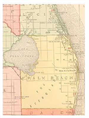
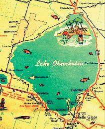
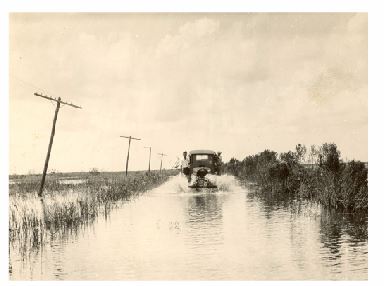
Although several hurricanes have struck Palm Beach County, none caused as much loss of life and property damage as did the catastrophic 1928 hurricane. This storm was equal to a Category 4 hurricane. Strong winds and heavy rain caused Lake Okeechobee to overflow. Belle Glade, Pahokee, Canal Point, and South Bay flooded. Flooding and high winds damaged or destroyed almost everything in the hurricane’s path, killing about 3,000 people in the Glades. As a result, the Herbert Hoover Dike was built around Lake Okeechobee. Residents have learned to prepare for hurricanes. Evacuation routes have been established for those living along the coast. Meteorologists keep the public informed when a hurricane is approaching, so people can prepare. In 2004, Florida was struck by four hurricanes–Charley, Frances, Ivan, and Jeanne–which was very unusual.

A FEW MAJOR PALM BEACH HURRICANES

September 18, 1926: The Great Miami Hurricane cut a swath of destruction from the Upper Keys to St. Lucie County, causing about
$75 million in damages and killing at least 372 people.

September 16, 1928: The storm of 28 devastated Palm Beach County flooding the Glades area, killing at least 3,000 people.

September 17, 1947: A hurricane caused a storm surge of up to twenty-two feet around Lake Okeechobee; the dike held.

October 12, 1947: A hurricane hit Lake Okeechobee on the west and dumped large amounts of rain on the Everglade. It flooded most of the agricultural land south of Lake Okeechobee.

August 26, 1949: A hurricane hit Palm Beach County and the Treasure Coast, causing at least $1 million in damage at Palm Beach International Airport. The Lake Okeechobee dike and flood system helped reduce damage.

August 27, 1964: Hurricane Cleo caused $50 million in damage in Palm Beach County.

October 14, 1964: Hurricane Isbell crossed the Everglades, striking Palm Beach County. Twenty-two mobile homes were destroyed by tornadoes; one man died in Lake Worth.

September 3, 1979: After killing a thousand people in the Caribbean, Hurricane David moved along the coast of Palm Beach County, causing $30 million in damages.

Play Video

History of Florida Weather

Florida has a history of extreme weather that has shaped the land. Watch this video to learn about Palm Beach County weather.